Flying With Real Weather
FOR FS 2002, FS 2000, and FS 98
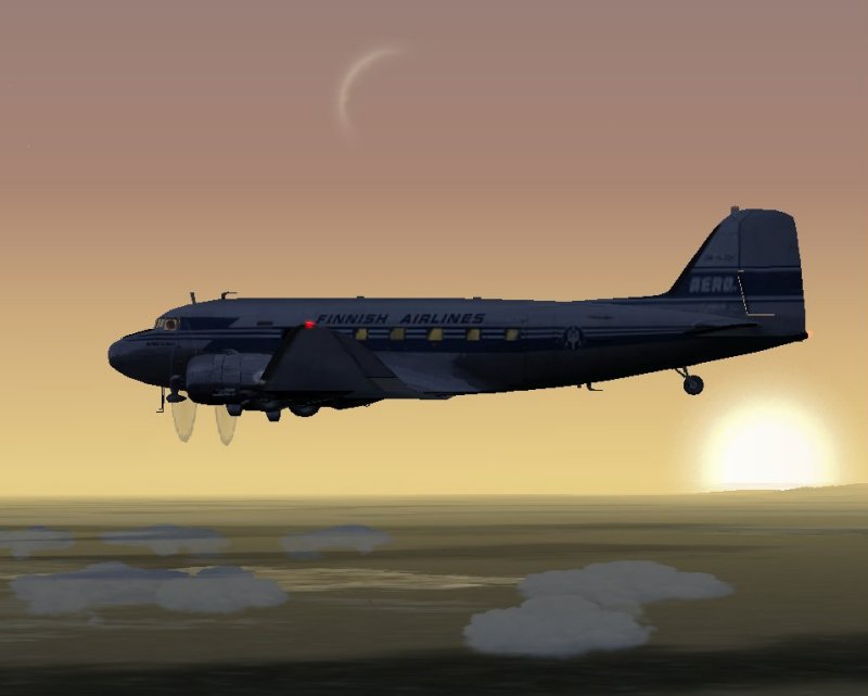
Those FS2002 and FS2000 flyers who have yet to discover the joys, trials, and tribulations of Real-World Weather (R-WWx, henceforth), and FS98 flyers who have not tried the third-party freeware add-on, Real Weather 5 (RWx5) are missing a big aspect of flight sim and especially the full VA experience. I'm a firm believer that virtually every flight should be a real weather flight. The endless variety and outright surprises that the "changing" (I'll explain that later) weather can hand you will add a lot of spice to what might otherwise be a rather bland flight from point A to point B. With practice, after all, you can control everything else about your flight. But you can’t control the weather -- when it’s real!
In FS2002, Microsoft incorporated a Real-World Weather capability in the sim
for the first time and the capability has been carried forward into FS2002,
with a few improvements. In cooperation with Jeppesen, the aeronautical
chart people, MS has designed this utility so that users can download
weather data reported from all over the world and plug it in to the FS2K /
2K2 weather generator, semi-automatically. In fact, it's incredibly easy to
use and nearly fool proof. You must have an on-line connection to download
the data, but you need not remain on-line during your flight. What a lot of
sim flyers don't realize, though, is that this idea, like a lot of the best
features in FS, began life as a third-party freeware concept.
There are a number of different weather programs around, some of which are
just expansions of FS's random weather generator. But one that does more and
probably inspired the guys at MS is Real Weather for FS95 and 98 by Jeff
Wheeler. I used it extensively and recommended to all our pilots at my old
VA. Of course that was before the advent of FS2000. The FS2K / 2k2 R-WWx is
much easier and faster to use, but the RWx5 for FS98, while rather ponderous
and time-consuming to set up, actually has some nice additional
capabilities.
FS 2000 / 2002 REAL WORLD WEATHER
1. Start your on-line connection (if your system is configured to
automatically connect, you can skip this step).
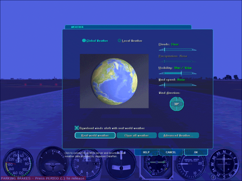
2. Open the World / Weather pull down menu (key board Alt + w + w)
3. Ensure that the Global Weather box is checked (OK, so it's a circle and
you put a dot in it -- you know what I mean).
NOTE: If you download weather data with the Local box checked, that's all
you are going to get. Outside of the area where your plane is located at the
time you make the download, you will not have realistic weather. This means
that if you fly out of the local weather area you may encounter completely
different weather conditions and no transition - you could be in a blizzard
one minute and a hot sunny day the next.
3. Push the Real-world Weather in the Weather dialogue box. (Keyboard R)
4. (FS2002 Only) Check the "Download winds aloft with real-world weather"
box, if desired. (Why not? It's supposed to be real, right?) Note: See the
section below on Winds Aloft.
That's it. The sim will take it from there, opening a connection to the
Jeppesen website, downloading the latest available weather, and then loading
it into FS's weather generator. At the end of this short process the weather
will be updated and you will most likely see a change outside the plane. The
whole connection, download and update process will take you perhaps a minute
or less on a 56K modem, and under 10 seconds on a broadband connection.
Before closing the Weather dialogue box, switch to Local weather and push
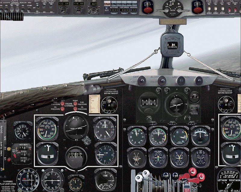
the Advanced Weather button, then note the current conditions where you are.
You will need this in flight planning, in particular, for selecting your
takeoff runway and departure routing. Because it's so fast and easy, even on
the relatively short flights on the DC-3 Airways schedule, you may want to
do it again before you start your descent to destination, just to be sure
you have the latest conditions. At this time, take a look at the Advance
Weather again for use in modifying your planned approach, if necessary. (See
the section below on Remote Weather Station Reports in FS2000). You may even
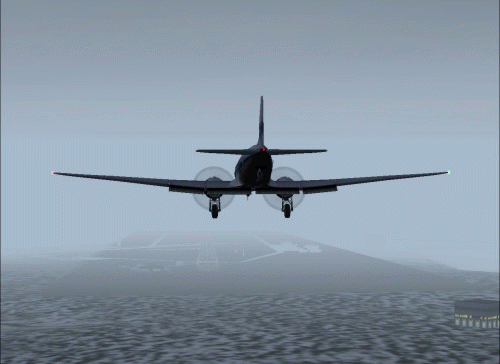
have to divert, as I did the other night when I found Montpelier socked in
and had to proceed to my alternate, Burlington. The runway lights looked
mighty fine when they finally burned through the fog at 600 AGL! This is one
example of the sort of adventure I was talking about. You may break into an
unexpected shower when descending below the overcast, as I did at Boston a
while ago. Perhaps you will find yourself in the midst of a snow squall
enroute, only to have the sun break through as you make your approach.
During the course of your flight, the weather gives the illusion of
"changing" because you are moving from one area to another. The weather
conditions at any given spot will actually remain constant, unless and until
you download again, and only then if there have been both an update from
Jeppesen and a change in reported conditions. I do not know how frequently
Jeppesen makes updates, but I usually find a close correlation with what the
FS2000 Advanced Weather info is showing and what I see outside my window, or
hear reported from KADW- Andrews AFB or KBWI Baltimore-Washington
International, depending on weather I'm at work or at home. Try it with your
own home field. You may be amazed at how closely the vastly improved weather
modelling and depiction of FS2000 and FS2002 mirrors the real thing.
One last item about FS's R-WWx -- Is the "Global" Real Weather download
truly global, or are only North American reporting stations considered? I'm
happy to report that it is global indeed. I checked the MS Advanced Weather
at Tokyo, London, and Sydney after a R-WWx download against the
http://www.intellicast.com reports
of current conditions for those cities. They exactly coincided.
WINDS ALOFT
FS2002 has added a new feature to its R-WWx capability, namely a Winds Aloft download. The Weather dialogue window now has a box labelled "Download winds aloft with real-world weather". When this box is checked, in addition to the normal weather parameters that were downloaded by FS2000, you can also include winds aloft - meaning, at altitude, as opposed to the wind at ground level.
REMOTE WEATHER STATION REPORTS IN FS 2000/2002
To get a report for remote locations in FS2000 and 2002 open the Weather dialogue box and check Local to open the map. Click the little triangle beneath the Weather Reporting Station code (not all of them are at airports) that you wish to check. The symbol will turn red and the station's name and location will appear beneath the map.
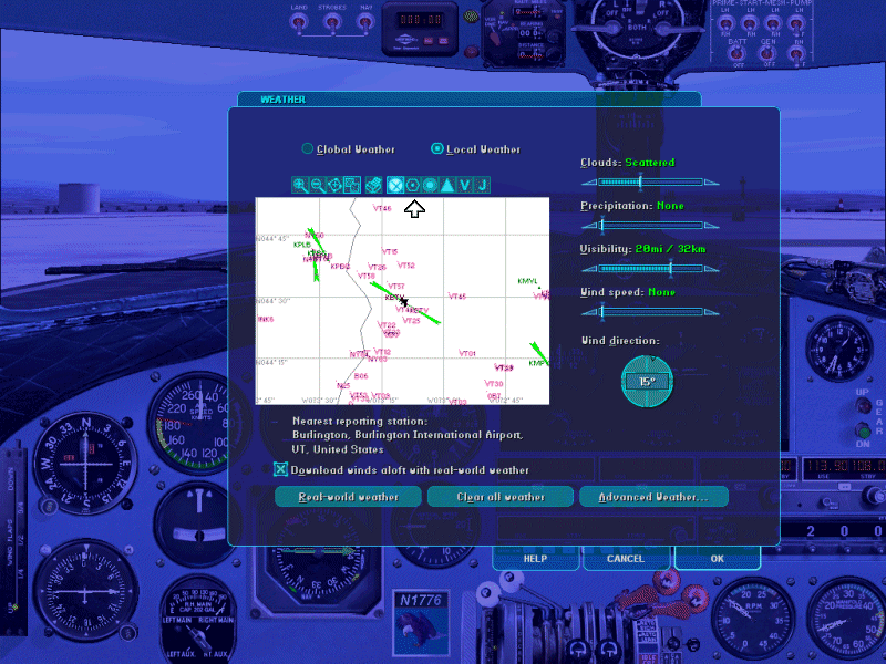
Now you can push the Advanced Weather button and read the conditions for the selected weather reporting station. The disadvantage over the RWx5 reporting function is that you need to pause your flight to do it, not a big deal in pre-flight planning. But perhaps more aggravating is there is no search function. You better know where the station is on the map, then you have to manipulate the mouse to bring it into frame.
FLYING YOUR ROUTES WITH REAL WEATHER
You will soon learn that when you fly with real weather some of the
instructions in the description for your flights won’t work anymore. You
should not take off on runway 34, for instance, when you have a 15-knot
breeze blowing out of the south! Neither should you land on a specified
runway if there is an appreciable wind from a direction that favors another
runway. That’s just good flying sense and safety. I don’t think the Boss is
going to send you back to remedial flyboy training for deviating from
instructions! What you will be doing is what real pilots have to do, think
on their feet and adapt as the weather changes.
What's more, with the advent of FS2002's Artificial Intelligence Traffic
(the other planes you see flying around your FS world), you darn well better
pay attention to the wind and runway selection. Otherwise you may meet a
jumbo jet landing or taking off right at you! If you use FS2002's Air
Traffic Control Feature, you will be directed to the proper runway for an
upwind landing, anyway.
FSNavigator is a wonderful tool to accomplish the planning this entails,
both before you strap in and after. If you don’t have it yet and have not
taught yourself to use it, do so. Even if you own a full set of charts and
approach plates, this program makes it easy and fun. If you get to your
destination and find you can’t get in because of low visibility or severe
conditions such as a killer crosswind, don’t risk the airplane or the
passengers. Instead, go to an alternate airport. Didn’t plan for it? Oops.
All is not lost, even if you are, temporarily. You do not have to hit the
nasty P key, either (although I bet real airline pilots wish they could, at
times!). Instead, engage the automatic holding pattern mode of the Sperry.
You didn’t know there was such a thing? ;-) Here’s what you do:
1. Turn the Sperry’s Rudder control adjustment wheel (the left-hand one) all
the way down to zero.
2. Turn on the Sperry’s Master Switch.
3. Set the other two adjustment wheels at normal settings (around 1 for
FS2002 and 3 for FS98 and 2000).
4. Manipulate the Elevator knob to maintain a level altitude, then crank in
a comfortable bank angle on the Aileron knob.
5. Once the bank is established, fine-tune the elevator knob to hold your
altitude.
6. Tell George (your still-wet-behind-the-ears co-pilot) to watch
everything, but not touch anything!
7. Now, break out the charts (FSNavigator) and decide on your next course of
action.
8. Try to complete steps 1 through 7 before you run out of fuel.
Now here's where that map in the FS2000/2002 weather dialogue box that we
discussed above comes into its own. It's the cat's meow for helping you
select an alternate airport when your primary is below minimums.
DETERMINING THE ACTIVE RUNWAY
There are a number of ways you can determine (or at least make an
educated guess) as to which is the active runway - the one being used for
takeoffs and landings - at a given airport. In FS, the active runway is
determined by wind direction since you should always land and takeoff into
the prevailing wind, of course. In real life, other factors might enter into
the picture, including runway length and condition. At larger airports,
there may be multiple active runways in use. Usually, in FS we are talking
about one active runway, though. We'll go into the times when that is not
the case a bit further on.
First of all, let me repeat that when you start a session of FS, whether it
be 98, 2000, 0r 2002, you should ALWAYS do so using a default aircraft. The
most sensible way is to simply use the one called "Default Flight - Meigs
Field" - the Cessna flight which has always been the default start flight
for all versions of MSFS. The reasons for this are several and have been
covered in the manuals for the R4D and N1776. All I'll say here is that if
you are having problems with your plane or one of it's systems, a switch to
a default plane can often set them right. But there is an additional reason
to do this from a weather standpoint, and it has to do with determining the
active runway for takeoff at your intended point of origin. That is method
number one...
1. After loading the "Default Flight - Meigs Field" flight:
a. Download the Real-World Weather.
b. Select your preferred DC-3 using the Aircraft / Select Aircraft menu.
c. Use the World / Go To Airport menu, or Flights / Flight Planner menu
(FS2k2) to place your DC-3 on the active runway at your departure field.
d. If you wish to start from a gate, note the runway where you were placed
and use the menu again to move to the gate.
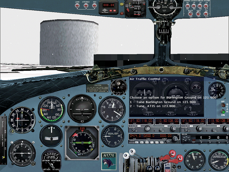
If you use FS2002, another of its new features, Air Traffic Control, offers
an even better and faster way of determining the active for airports with an
ATIS (Automatic Terminal Information Service) .
2. (2k2) The procedure is the same as above, except...
a. Go straight to the gate or ramp of your departure station.
b. Hit the ` key (the key preceding the 1, with the tilde [~] on top) to
bring up the Air Traffic Control window.
c. If the airport is equipped with an ATIS station, tune it by hitting the
correct number key. The "landing and departing runway..." part of the
recorded message specifies the active runway, of course.
OK, so what if the airport does not have an ATIS? Well, you can check the
World / Map View and locate the nearest airport with an ATIS and use that,
if you are in radio reception range. But if yours is a small airport,
without a tower, selection of the active runway is your decision as pilot in
command. Look around for the windsock, if there is one, or hit Shift + z and
read the wind direction. To select the active runway, you want the runway
direction closest to the wind direction. The idea, of course, is to put the
wind as far forward as possible, thereby reducing the effect of crosswind.
If the runway selection not readily apparent, here's how you figure it out:
Add a zero on the end of the runway designator -- for example, Runway 28
becomes 280, and Runway 10 becomes 100. This gives you the rough runway
direction (within five degrees, plus or minus). Do this for each of the
runways and by subtracting the wind direction from the runway directions,
(or vice versa, depending on which number is larger) determine which is
closest to the prevailing wind direction.
As an example, let's take Ass-Pirin Acres. I'll bet you think I made that
up! Well, I didn't. It's VT11 and has two runways - 1/19 and 10/28. The
grass runways are 3700 and 2600 hundred feet respectively, and unlikely to
be a port of call for your Douglas, but indulge me.
If your wind direction is 234 degrees, what runway is best, assuming they
are of roughly equal length and condition?
The two in the running would appear to be RW19 (190 degrees) and RW28 (280
degrees).
Runway 28: 280 - 234 = 46
Runway 19: 234 - 190 = 44
Runway 28 is your winner in a photo finish. Ah, but is it? If it's this
close, you should take a look at runway length. As in this case, the extra
1100 feet available on RW19 is a more important factor than that tiny two
degree difference in your crosswind. Usually, though, the decision is much
more clear cut and you won't have to do any calculations. In the example
above, a 20 degree wind makes Runway 1 (10 degrees) an obvious choice, for
instance.
There is one more factor to consider in determining the active runway --
what is other traffic doing? Are there aircraft taxiing to or from a runway?
Can you see other aircraft on approach or departing your airport? When all
is said and done, a possible collision with opposing traffic must take
precedence over the wind direction when selecting your runway. FS2002 does a
good (but reportedly not flawless) job of designating the active runway and
routing arriving and departing AI aircraft according to wind direction. FS98
and FS2000, on the other hand have dynamic scenery traffic which always land
and depart (from certain major airports, only) in the same direction,
totally regardless of the wind direction. If you are operating at a major
field with dynamic scenery, I recommend you turn it of, unless you know they
will not pose a conflict.
However, if you have the excellent add-on for FS98 and FS2000, FS-Traffic,
by Lago, it does switch traffic patterns with the wind. But there is one
factor you will need to take into account with FS Traffic. Since it only
sets up aircraft to use ILS equipped runways, you may find that what seems
the obvious active runway according to the wind may not be the one being
used by FS Traffic aircraft. FS Traffic will select the best ILS equipped
runway, not the best runway overall. So, you could find yourself in a
crossing situation with other traffic, though not directly opposing. This
happens at busy airports all the time. I'll use one of my home fields as an
example - Reagan National Airport KDCA, where the runways are 1/19, 4/22,
and 15,33. The longest runway is 1/19 and in FS Runway 1 is ILS equipped,
while 4 and 33 are not. So FS Traffic will run airplanes into and out of RW1
with any sort of northerly wind. So if you are using 33 in a brisk breeze of
15 knots from 320 degrees, you may well encounter another plane at the
runway intersection if you aren't careful. In real life, you would be spaced
out by approach control and the tower to avoid such conflicts, or one or the
other of you would be asked by the controller if you could stop short of the
intersection. IN FS98 and 2000, you will have to do double duty as PIC
(pilot in command) and ATC. Try not to bend anything.
FS2002 TIP: If you are trying to make sense out of the movement of taxiing
aircraft to give you a clue as to the active runway but can't figure it out
because of distance or intervening buildings, hit the Ctrl + s key for a
Top-Down view. You'll have a bird's eye view of the comings and goings at
the airport.
MORE ON ATC
All right, all you FS98 and FS2000 types (why are you holding out?) will have to excuse me now, as I'm going to talk further about FS2002's ATC feature. ATC is, without a doubt, your best method of determining the active runway, and I think, the best way to start your flight. You say you do not want to be directed by ATC because it will make you deviate from your DCA flight plan? It's not within the scope of this article to discuss all the nuts and bolts of FS2k2 ATC and how it may be adapted to our flight plans. But you may certainly use ATC Instead I will explain how to determine the active runway from ATC, but leave yourself free, if you wish, to do your own thing...
TAKEOFF
First, you must file a flight plan in FS2002. Here's how:
1. Using the FS2002 / Flights / Flight Planner menu (keyboard shortcut - Alt
+ f + p), select your Departure Airport. While you are at it, select your
starting position at the gate. Sure, you could cheat here and select "active
runway" and be done with it, but we have covered that already, and anyway,
now we are talking about actually beginning your flight. You joined a VA to
do it realistically, right? So begin your flight at the gate. Go through the
checklists, start the engines (don't forget to close the door!) and taxi to
the active. Oh yeah, we still have to determine that...
2. Choose your Destination Airport
3. Select IFR, regardless of whether you will fly IFR or VFR. (Trust me on
this. ATC will not give you the information you are seeking if you file
VFR.)
4. Make a routing selection. Just stay away from the "high altitude airways"
-- yours is an unpressurized aircraft , remember?
5. Hit the Find Route button.
6. Hit the Save button, then OK, then OK again (at the bottom of the Flight
Planner dialogue box).
OK, you are filed and ready to go. (you did all that checklist stuff,
right?) Here we go...
1. Hit the ` key to bring up the ATC dialogue box (drag and size it, if you
wish).
2. Tune the Clearance Delivery frequency by hitting the indicated number
key.
3. Request your IFR clearance.
4. Tune Ground Control.
5. Request Taxi Clearance. Ground control will direct you to the active
runway and tell you which taxiways to use to get there. TIP: Progressive
Taxi Instructions will give you a big pink line to follow - what more could
you ask?
6. When you reach the "hold line" short of the runway, contact the tower and
request takeoff clearance.
7. After your handoff to departure you can request cancellation of IFR and
continue on your way using your FSNavigator flight plan, or continue on with
ATC direction to your destination. If you cancelled IFR, you can still get
guidance from ATC when making your approach...
LANDING
1. Bring up the ATC box and choose "Select Airport Option".
2. Choose your destination airport from the displayed list. (If it's not on
the list, you are still too far away. You can leave the list on screen and
it will refresh as you move along.)
3. Listen to the ATIS or Automated Weather.
4. Tune the tower and request a full stop landing.
5. The tower will tell you tell you the active runway and the pattern (left
or right) to fly. When you are on approach, the tower will issue your
landing clearance.
You will find that FS2002's ATC is very intuitive and easy to use. It's not
perfect, and there are some things it can not do, but it's still one of
FS2002's best features. The auto-tune feature is as good as having a
competent co-pilot to handle the radios. The ATC calls to and responses from
AI aircraft that, in some cases, you may actually be able to see in your
section of the sky, add a whole new dimension to the flight sim experience.
Yes, the other planes do follow ATC direction, too. Don't be surprised to be
issued a go-around command, either, if there is a traffic conflict. Give ATC
a try, if you have not already done so. Real-World Weather and Air Traffic
Control are an unbeatable combination for a lifelike flightsim experience.
Speaking as a VA pilot who has flown around the world three times in real
time with real weather, it’s my bet that once you fly with Real Weather,
whether the weather is in FS2000, or whether it’s FS98 weather, you’ll never
go back to plain wrapper, canned weather. There's a whole world of
meteorological variety and adventures awaiting you.
Happy Landings - Tail Low , weather permitting…
Bill Rambow
DC3-047