Flight Altitudes
Terrain and Obstruction Clearance
But a pilot's primary concern is to select a flight altitude which provides safe clearance over the local terrain and other obstructions. Sectional charts for VFR flight and Low Altitude enroute charts for IFR flight provide the information for that decision.Consider first the Sectional chart. The illustration below shows a segment from the Halifax Sectional chart, near the familiar Stonington Airport, 93B, from type-rating flight No. 1202.
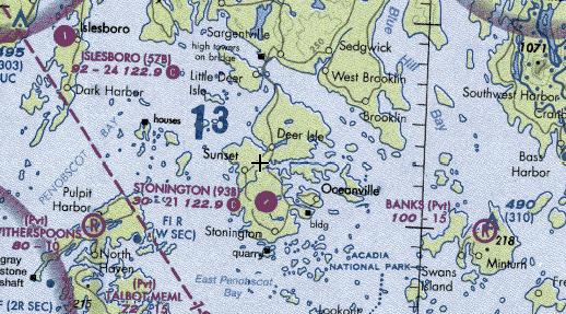
The bold "13" north of Stonington Airport is the Maximum Elevation Figure for that grid-square. The large digit(s) on the left, here a one, is the thousands of feet above MSL and the digit on the right is the hundreds of feet above MSL. For this grid the highest elevation of anything, terrain, obstructions, towers, antennas, etc., is 1300 feet MSL. Every grid square on a sectional chart has such a notation.
When flying in this grid square the pilot knows that 1300 ft is the highest obstruction of any sort. But he can't choose 1300 ft for a flight altitude because that provides no clearance above the obstructions. A minimum of 1000 ft. should be added to the 1300 ft, establishing 2300 ft as the minimum altitude to fly in that grid square. If the route of flight passes through grid squares with higher obstruction altitudes, they should determine the minimum safe flight altitude. If the flight will be IFR, ATC will tell you which altitude is approved for your flight. But it's still worthwhile knowing what the minimum safe altitude is for the IFR flight.
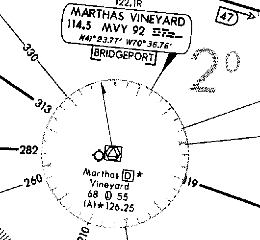
The Bold 2o NE of Martha's Vineyard is the obstruction clearance altitude for that grid on the chart. The obstruction clearance altitude provides a minimum of 1000 ft. clearance above any obstruction within that grid square.
The DC-3 ... Unpressurised
One concern regarding flight altitudes for the DC-3 is that it is an
unpressurized aircraft. So it normally flew at altitudes from 5000 to 8500
ft. When that was inadequate for proper terrain clearance, the DC-3 might
briefly climb as high as 10,000 ft.
If the duration of flight at 10,000 ft, was 30 minutes or greater, the
pilots were required to don oxygen masks. Now, civilian pilots hate oxygen
masks, I mean they HATE oxygen masks, so it was usually an uncontrollable
set of circumstances that forced them to altitudes requiring masks. The
additional concern about flight above about 8500 ft was the comfort and
safety of the passengers in the back cabin. Oxygen masks were not available
for them, although the aircraft carried portable oxygen masks tied to an
oxygen bottle for emergency situations.
VFR Flight
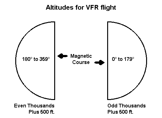
If your VFR flight is above 3000 ft. AGL (Above Ground Level) when flying
a magnetic course of 0° to 179° fly at ODD thousands of feet plus 500 feet.
In non-gov't. language, fly at 3500 ft. or 5500 ft., or 7500 ft. and so
forth if your magnetic course is from 0° to 179°.
And of course, from 180° to 359° magnetic course, your altitude should be
EVEN thousands plus 500 ft.—like 4500 ft., 6500 ft., 8500 ft., etc.
How does one remember that rule? It's easy. "Easterners are Odd" will do it.
If your VFR course is easterly, i.e., from 0° to 179° fly at odd thousands
plus 500 ft. Sounds like a Californian invented that memory aid.
If one leg of your flight is easterly and you are at 5500 ft., and the next
leg is to the northwest, need you change your altitude to adhere to the
rule? You sure do.
Notice that the term "magnetic course" has been carefully used throughout
this altitude discussion. With a crosswind, the aircraft's magnetic heading
will differ from the planned magnetic course.
For example, suppose your planned magnetic course home from a weekend at the racetrack is 005°. But a strong crosswind forces you to steer 355°. Your altitude will be determined by the magnetic course of 005°, i.e., follow the easterly rule to choose your altitude.
IFR Flight
Almost the same rule for IFR flight, except skip the 500-ft. part. So,
for those odd easterly flights, fly at 3000, 5000, 7000, or 9000 ft; and at
4000, 6000, or 8000 ft if west-bound.
Of course, on IFR flights, ATC defines your flight altitude. But don't worry
about your DC-3 being assigned a flight at FL-370, 37,000 ft, because
computers do the assignments, and we know computers never make mistakes.
Right?
Flight Levels
Note that, in the US and Canada, from 18,000 feet and above, the term Flight Level is used, rather than actual altitude. Drop the last two zeros of the altitude for the Flight Level. Thus, 24,000 feet becomes Flight Level 240, written FL240, and spoken Flight Level Two-Four-Zero.
Outside the US and Canada, Transition Rules are much more complex with no
universal setting. Unless you fully understand them it is suggested that
when flying with DC-3 Airways you use the Transition Rules for the US and
Canada.
When flying VATSIM or IVAO then request the TA and TL from the Controller
you are in contact with or refer to approach plates for that airfield.
Page revised 17 June 2008
Updated to current format and dead link removed 3 June 2021