WARNING: This information is outdated. FS Navigator is no longer available, except for version 4.70 hosted in our downloads section. The preferred flight planner is currently Little NavMap. Technical page coming soon.
FSNavigator
In my opinion, if you are not using FSNavigator you have only half a flight-simulator. Authored by Helge Schroeder, FSNavigator is a valuable mapping utility that shows the location of airports, navaids and your aircraft. One can zoom out to show the entire world or all the way in, so that a single airport occupies the full screen. Best of all, you can plot your planned flight path by clicking on the navaids, airports, or waypoints along the route of flight. It does a lot more, too. You'll wonder how you ever did without it.
The only problem is that you can no longer purchase the program.
Setting up FSNavigator for the DC-3.
You may setup FSNavigator with profiles of any aircraft desired. To setup
a DC-3 profile, load your Flight Simulator, press the F9 key to switch to
FSNavigator, and do the following steps:
- Click on the "Plan" tab on the vertical post of FSNavigator 4, or
the "Plan" tab in the upper left corner of FSNavigator 3.0.
- Click on "Aircraft" in the drop-down menu. Here is the data-entry panel that will drop down (for FSN ver. 4, see further below for FSN ver. 3):
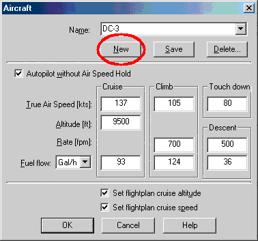
Aircraft Data-Entry Panel, FSNav 4.
- Click the "New" button and the Name window will go blank.
- Type in DC-3 in the Name window.
- Type all of the parameters shown in the figures above into your DC-3
data-entry panel.
- Click on the Save button next to the New button.
Why the Save button and the OK button?
You may find that most of your DC-3 flights are, for example, at 5500 ft.
So set up the aircraft information as above, but with 5500 ft in the
Altitude window and save it.
If you have one flight that you want to cruise at 9500 ft, enter 9500 ft in
the Altitude window, but DON't click Save, click OK. That changes the
information for just one flight, and leaves your altitude at 5500 ft for the
next flight.