- Welcome to DC-3 Airways Annual World Tour.

Recent posts
#71
General Discussion / ARD's Logbook WT2026 -(001)
Last post by Ard-WT - Oct 01, 2026, 06:02 AMFL01 LFML - LIMJ
This flight has a challenging T&G at Mont Dauphin Saint-Crépin LFNC, in a deep valley. To make it possible, you will have to descent earlier enough into the valley in order to make the descent and come to the airport elevation. I could only make the wheels touch down on the last 300 ft of the RW
After the T&G another challenge is to climb fast enough to pass the mountains to the East. I had to fly through the valley till Briancon and turn right into the valley of La Cerveyrette river to climb to 11,500 ft for the further flight. We made it and concluded with a safe landing.
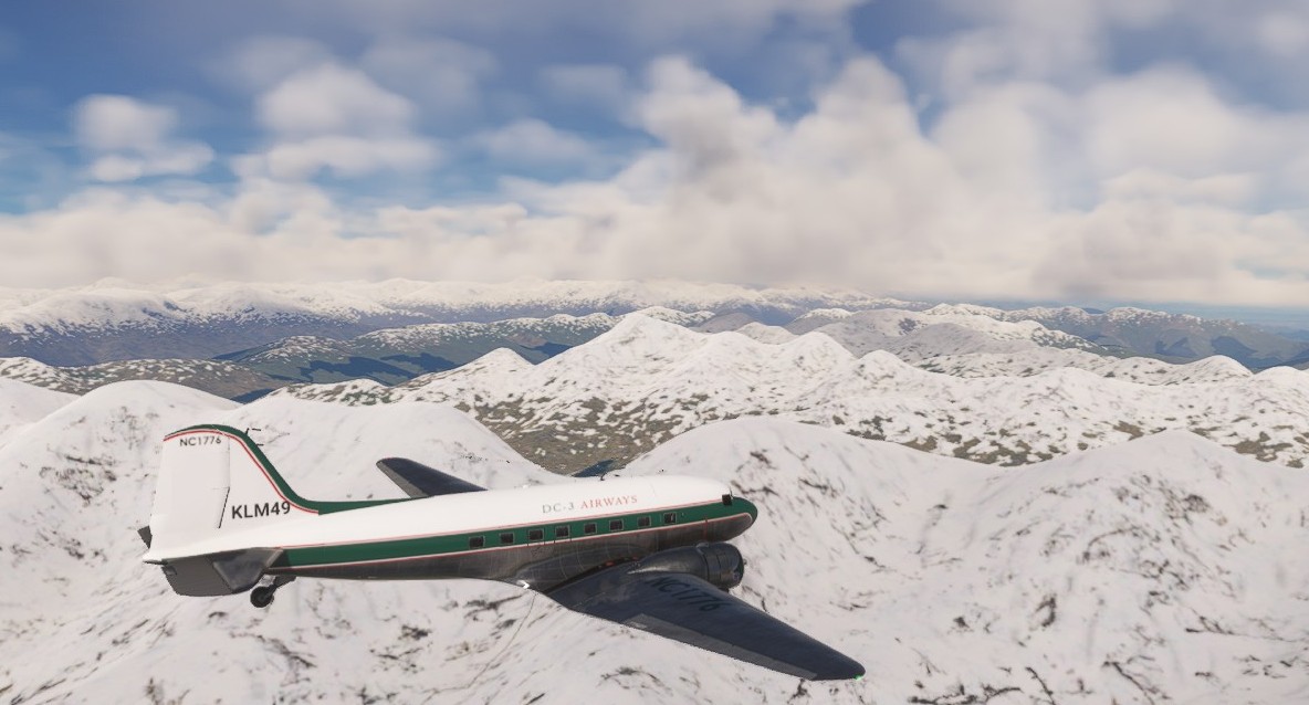
Fly over the snow mountains on the top of this flight
This flight has a challenging T&G at Mont Dauphin Saint-Crépin LFNC, in a deep valley. To make it possible, you will have to descent earlier enough into the valley in order to make the descent and come to the airport elevation. I could only make the wheels touch down on the last 300 ft of the RW
After the T&G another challenge is to climb fast enough to pass the mountains to the East. I had to fly through the valley till Briancon and turn right into the valley of La Cerveyrette river to climb to 11,500 ft for the further flight. We made it and concluded with a safe landing.
Fly over the snow mountains on the top of this flight
#72
General Discussion / PIREPS...
Last post by Alan1-WT - Oct 01, 2026, 04:35 AMAre we also allowed to file our World Tour Flight Times in the 'regular' DC-3 Airways PIREP System and receive Credit for the WT Flights?
Thanks, and Good Luck to All!
Alan Nakamura WT010/DCA2253
Thanks, and Good Luck to All!
Alan Nakamura WT010/DCA2253
#73
General Discussion / Re: Mt Ruapehu
Last post by 1161 Roy Möhlmann - Sep 29, 2026, 05:24 PMGoto Downloads, at the end of the lines click on FP01, ect.
Roy
Roy
#74
General Discussion / Re: Mt Ruapehu
Last post by Richard-WT - Sep 29, 2026, 11:14 AMGood afternoon
Which link or where would I find the tour / leg description pdf-file link please?
Richard S
Which link or where would I find the tour / leg description pdf-file link please?
Richard S
#75
General Discussion / Re: Mt Ruapehu
Last post by David-WT - Sep 28, 2026, 04:15 PMThank you. I was only reading the PDF description which did not have the actual latitude and longitude coordinates of the flight plan. So I read "overfly" to mean fly directly over the mountain. Thank you for the clarification.
Since I fly in VR, I don't use Little Nav Map or other stand-alone navigation apps. I also use the "classic" version of the plane in MSFS 2020, so I don't have GPS and depend on VOR's and NDB's or look at the VFR map.
Since I fly in VR, I don't use Little Nav Map or other stand-alone navigation apps. I also use the "classic" version of the plane in MSFS 2020, so I don't have GPS and depend on VOR's and NDB's or look at the VFR map.
#76
General Discussion / Re: .pin (FS9) flight Plan Req...
Last post by 1161 Roy Möhlmann - Sep 27, 2026, 12:56 PMThanks for all your help, Ard.
Roy
Roy
#77
General Discussion / Re: Mt Ruapehu
Last post by Ard-WT - Sep 27, 2026, 04:39 AMDavid_WT , you are correct, however the flight plan as offered by DC3Airways WT2026 is showing a course not over the top of Mt Ruapehu but more around it over the lower level flanks.
Suggestion
Maybe it would be better to make the flight plan and the text consistent.
- overfly Mt Ruapehu, with a flight plan over the top and the minimum altitude as 9500 ft, or better 10,000 ft to keep about 1000 ft clear of the top.
- fly around Mt Ruapehu over the flanks with the present flight plan route and a minimum altitude of 6500 ft.
#78
General Discussion / Re: .pin (FS9) flight Plan Req...
Last post by Ard-WT - Sep 27, 2026, 04:20 AMthan you are fine. the DC3 lnpln files as given in the desctiption can be loaded in LNM (littlenavmap). Once LNM has the fllight plan, you can export it as a FSX pln file.
And as You said, you have an option to convert a FSX pln file to FS9 .pln files
(btw now I learned that FS9 is also known as FS2004.)
And as You said, you have an option to convert a FSX pln file to FS9 .pln files
(btw now I learned that FS9 is also known as FS2004.)
#79
General Discussion / Mt Ruapehu
Last post by David-WT - Sep 26, 2026, 05:27 PMJust a quick note about Flight number 3. Mt Ruapehu in New Zealand is about 9200 feet tall. Trying to "overfly" it at 6500 feet is not going to end well.
Just sayin'
Dave K
Just sayin'
Dave K
#80
General Discussion / Re: .pin (FS9) flight Plan Req...
Last post by Alan1-WT - Sep 26, 2026, 03:00 PMThanks for the offer!
I have an older Copy of Plan-G that can convert FSX .pln Files to FS9 .pln Files since they are different. I don't know if the Software can convert MSFS2020 files, though.
I have an older Copy of Plan-G that can convert FSX .pln Files to FS9 .pln Files since they are different. I don't know if the Software can convert MSFS2020 files, though.